Oceano-meteorological buoy MARETO (Málaga)
Boya oceano-meteorológica MARETO (Málaga)
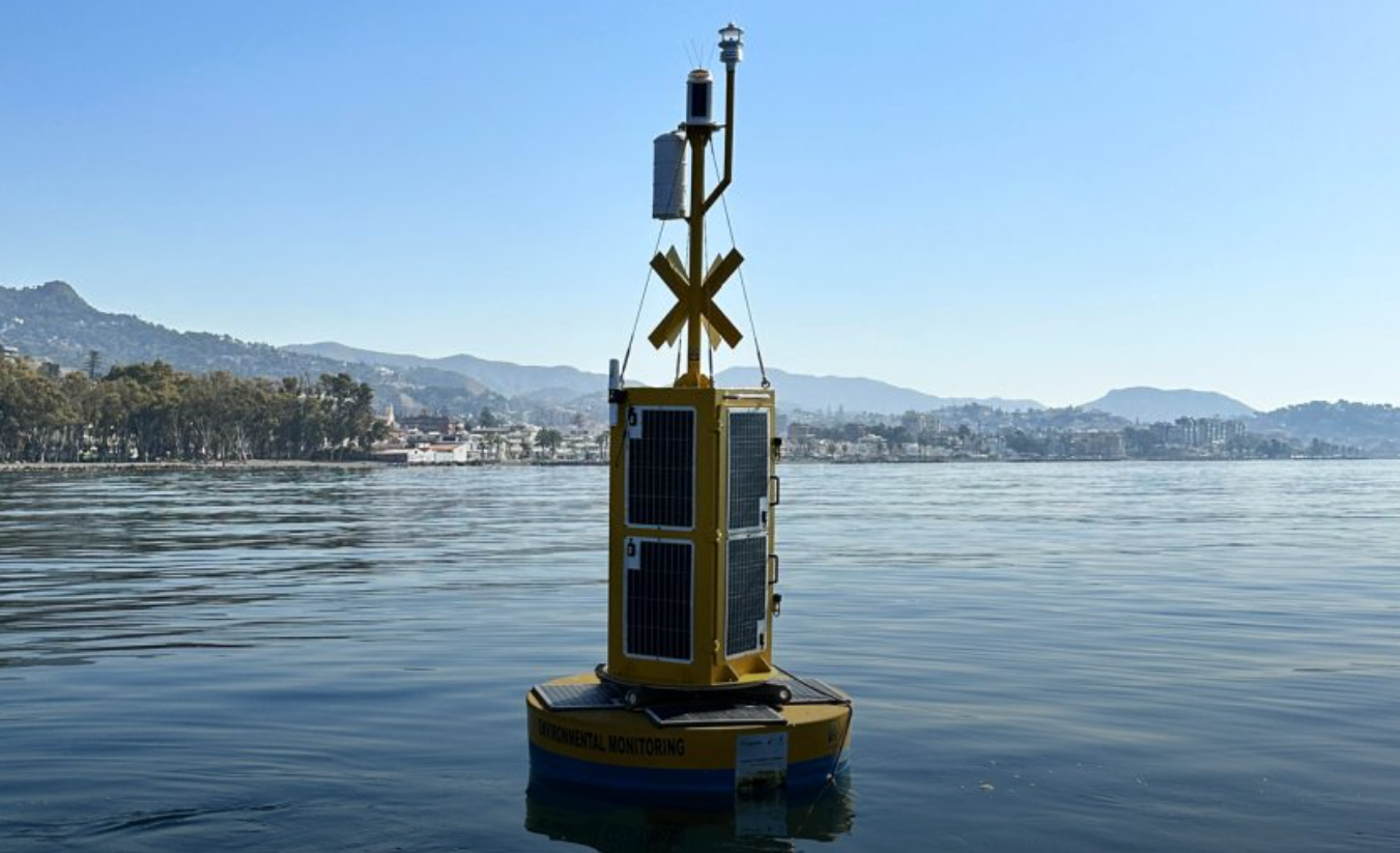
MARETO, the “Málaga Real-Time Observatory,” is an underwater observatory equipped with sensors that enable the real-time collection of oceanographic data for various studies under the LifeWatch Alborán project.
The infrastructure consists of a surface buoy and a submerged structure that protects the equipment installed inside. MARETO comprises:
LAND NODE. This is where the server with applications for monitoring and controlling the maritime node is located.
MARITIME NODE. It consists of:
- Surface Marine Node: Includes the buoy, mooring weights, power supply between the buoy and the underwater node, cable protection system, and acoustic profiler. The buoy houses the battery storage area, solar panels for powering the sensors and the communication node, antennas, and the meteorological station.
- Underwater Node: Includes the protective structure and the equipment inside it (CTD, sensors for measuring oceanographic variables, hydrophone, and cameras).
The buoy’s structure is designed to withstand the tension generated by the underwater cable. It contains the control electronics for the observatory, which allow for the connection of various sensors. The buoy is located in front of the Balneario del Carmen. With a length of 550m and a width of 15m.
MARETO “Málaga Real Time Observatory” es un observatorio submarino equipado con sensores para la obtención de datos oceanográficos en tiempo real, que sirven para la realización de distintos estudios objeto del proyecto LifeWatch Alborán.
La infraestructura está constituida por una boya en superficie y una estructura en profundidad que permite la protección de los equipos instalados en su interior. De esta manera, MARETO se compone de:
NODO TERRESTRE. Donde se encuentra el servidor con las aplicaciones que monitorizan y controlan el nodo marítimo.
NODO MARÍTIMO. Formado por:
- Nodo marino en superficie: compuesto por la boya, los amarres de los lastres la boya, la alimentación entre la boya y el nodo submarino, el sistema de protección del cable y el perfilador acústico. Sobre la boya se localiza la zona de almacenamiento de baterías y módulos solares para el suministro eléctrico de los diferentes sensores y del nodo de comunicación, se localizan también las antenas y la estación meteorológica.
- Nodo submarino: compuesto por la estructura protectora y los equipos que están dentro de la misma (CTD, sensores para la medida de variables oceanográficas, hidrófono y cámaras).
La estructura de la boya está diseñada de tal forma que puede soportar la tracción que genera el cable submarino. En ella se ubica la electrónica de control del observatorio, que permite la conexión de distintos sensores. La boya se encuentra frente al Balneario del Carmen, con 550m de longitud y 15m de ancho.
Simple
-
Alternate titleTítulo alternativo
-
MARETO buoy
Boya MARETO
-
Fecha (Creación)Date (Creation)
- 2025-06-01T00:00:00.000Z
-
Identificador del ContactoCitation identifier
- 15ce70a8-aa08-468e-9c80-905fce46bcb7
- Cited responsible party
-
Organisation name Individual name Electronic mail address Role IEO-CSIC, Malaga Oceanographic Centre
IEO-CSIC, Centro Oceanográfico de Málaga
OrígenOriginator
-
EstadoStatus
-
TerminadoCompleted
-
GEMET - INSPIRE themes, version 1.0
-
-
Oceanographic geographical features
-
-
SeaDataNet Ports Gazetteer
-
-
Spain
España
-
-
SeaDataNet Ports Gazetteer
-
-
Málaga
-
-
International Standards Organisation countries
-
-
Spain
España
-
-
International Standards Organisation countries
-
-
Spain
España
-
- Keywords
-
-
Oceanographic buoy
Boya oceanográfica
-
buoy
boya
-
-
SeaDataNet Platform Classes
-
-
moored surface buoy
boya de superficie amarrada
-
-
SeaVoX salt and fresh water body gazetteer
-
-
Mediterranean Sea
Mar Mediterráneo
-
Alboran Sea
Mar de Alborán
-
-
SeaVoX salt and fresh water body gazetteer
-
-
Alboran Sea
Mar de Alborán
-
-
SeaDataNet Parameter Discovery Vocabulary
-
-
Temperature of the water column
Temperatura de la columna de agua
-
Salinity of the water column
Salinidad de la columna de agua
-
Dissolved oxygen parameters in the water column
Parámetros de oxígeno disuelto en la columna de agua
-
Variable fluorescence parameters
Parámetros de fluorescencia
-
Turbulence in the water column
Turbulencia de la columna de agua
-
Ph of the water column
Ph de la columna de agua
-
Wind speed and direction
Velocidad y dirección del viento
-
Air temperature
Temperatura del aire
-
Air pressure
Presión atmosférica
-
Atmospheric humidity
Humedad atmosférica
-
Solar radiation
Radiación solar
-
Horizontal velocity of the water column (currents)
Velocidad horizontal de la columna de agua (corrientes)
-
Vertical velocity of the water column (currents)
Velocidad vertical de la columna de agua (corrientes)
-
-
SeaDataNet device categories
-
-
meteorological station
estación meteorológica
-
termosalinographs
termosalinógrafos
-
aquadoppler surface
AquaDoppler superficie
-
-
projectproject
-
-
Use limitationLimitación de uso
-
Not applicable
No aplicable
-
Restricciones de AccesoAccess constraints
-
Otras restriccionesOther restrictions
-
Other constraintsOtras limitaciones
-
by negotiationpor negociación
-
IdiomaLanguage
- English
-
CodificaciónCharacter set
-
UTF8UTF8
-
Categoría temáticaTopic category
-
-
OcéanosOceans
-
))
- Begin date
- 2019-08-18T23:00:00Z
- End date
- 2019-08-29T17:00:00Z
-
Identificador del Sistema de ReferenciaReference system identifier
-
World Geodetic System 84SeaDataNet geographic co-ordinate reference framesL102011-03-02 3 https://www.seadatanet.org/urnurl/SDN:L10
- Distribution format
-
Name Version XML
1
Unknown
Unknown
- OnLine resource
-
JerarquíaHierarchy level
-
campañascampañas
Conformidad del Resultado
Conformance result
-
Fecha (Publicación)Date (Publication)
- 2010-12-08
-
Explanation
-
See the referenced specification
-
AprobadoPass
- Yes
Conformidad del Resultado
Conformance result
-
Fecha (Publicación)Date (Publication)
- 2010-12-08
-
ExplanationExplicación
-
See the referenced specification
Consulte la especificación referenciada.
-
AprobadoPass
- Yes
-
StatementDeclaración
-
The data centres apply standard data quality control procedures on all data that the centres manage. Ask the data centre for details.
Los centros de datos aplican procedimientos estándar de control de calidad de datos en todos los datos que gestionan los centros. Solicite detalles al centro de datos.
Metadata
-
Identificador del ficheroFile identifier
- 15ce70a8-aa08-468e-9c80-905fce46bcb7 XML
-
Idioma del metadatoMetadata language
- English
-
CodificaciónCharacter set
-
UTF8UTF8
-
JerarquíaHierarchy level
-
Conjunto de datosDataset
- Hierarchy level name
-
Cruise Summary record
-
FechaDate stamp
- 2025-09-30T08:57:28.942994Z
- Metadata standard name
-
ISO 19115/SeaDataNet profile
- Metadata standard version
-
1.0
- Metadata author
-
Organisation name Individual name Electronic mail address Role IEO-CSIC, Spanish Oceanographic Institute
IEO-CSIC, Instituto Español de Oceanografía
Punto de ContactoPoint of contact
- Other language
-
Language Character encoding Spanish; CastilianSpanish; CastilianUTF8UTF8EnglishEnglishUTF8UTF8
Overviews
Spatial extent
Provided by