Monitoring of wetlands in Andalusia (Spain) with data obtained using multiparametric sensors
The project "Application of new technologies for ornitolimnological monitoring of wetlands in Andalusia" is a project of the IDi department of AMAYA. The need arises when it is identified that the monitoring of sensitive wetlands in Andalusia was left incomplete by analyzing only the bird community, and not integrating the physicochemical characteristics of the water mass on a continuous basis. It was necessary to have knowledge of specific incidents in real time that would allow space managers to act (dumps, sudden changes in temperature, etc...).
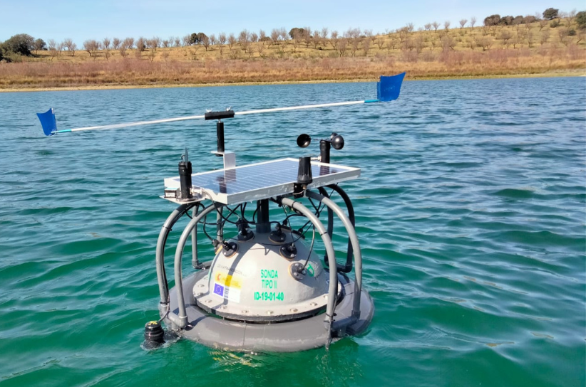
To respond to this demand, in 2019 a first prototype (5 units) of multiparametric probes was made, installed on watertight buoys that are energy autonomous and that, connected to the Internet, share the information to a cloud system. Every 2 hours, 5 environmental and aerial measurements are taken (temperature, barometric pressure, wind direction and intensity and GPS position) in addition to 10 submerged variables (Temperature at 4 depths, pH, Dissolved oxygen, Turbidity, conductivity, salinity, nitrates, chlorophyll, ultrasound depth). This system processes the measurements taken by the probe and assesses the need to generate an alarm to the space managers so that they can make decisions if necessary. The system can be accessed through a mobile App or through a web portal from any device connected to the Internet.
Monitoring has been expanded thanks to the financing of the INDALO project, which has allowed it to redesign part of the software and hardware, reduce maintenance, extend the equipment maintenance period until 2028 and expand the fleet with 7 more probes. This boost to the project allows us to establish a unique and innovative monitoring network for sensitive wetlands in Andalusia, which allows us to detect major threats to these very vulnerable ecosystems and the species that inhabit them. The buoys are installed in Huelva, Málaga, Córdoba and Almería, and the new installations are intended to reach the rest of the provinces. Each probe aims to analyze specific problems of each wetland as a contribution of phytosanitary products to the lagoon basin, assess the impact of the introduction of invasive exotic species, assess worrying processes of salinization or control of the conditions where an endangered species such as the Fartet (Aphanius iberus).
The project has a scientific committee led by the Department of Ecology of the Faculty of Experimental Sciences of the University of Jaén, although there are also several universities and research centers that have shown interest in the information generated, for the methodology applied and the resolution. that it has. Within the framework of the INDALO project, the probes will provide information as laboratories to assess the effects generated by Climate Change.
Simple
- Date (Publication)
- 2024-12-10
- Presentation form
- Digital table
- Purpose
-
Monitoring and alert system in real time to control the physicochemical characteristics of the water mass on a continuous basis to complement the monitoring of birds in wetlands
- Status
- On going
- Point of contact
-
Organisation name Individual name Electronic mail address Role Red de Información Ambiental de Andalucía (REDIAM) - Junta de Andalucía
Servicio de Análisis de la Información Ambiental - Consejería de Sostenibilidad y Medio Ambiente - Junta de Andalucía. - España
Author
- Maintenance and update frequency
- Daily
- Metadata author
-
Organisation name Individual name Electronic mail address Role Red de Información Ambiental de Andalucía (REDIAM) - Junta de Andalucía
Servicio de Análisis de la Información Ambiental - Consejería de Sostenibilidad y Medio Ambiente - Junta de Andalucía. - España
Publisher
- Theme
-
-
wetland
-
lagoon
-
limnology
-
- Place
-
-
Andalusia, Spain
-
- Keywords
-
-
GEMET - INSPIRE themes, version 1.0
-
-
Environmental monitoring facilities
-
Hydrography
-
- Access constraints
- Other restrictions
- Use constraints
- Other restrictions
- Other constraints
-
Creative Commons Attribution 4.0 International Public License (CC BY 4.0)
- Spatial representation type
- Text, table
- Language
- Spanish; Castilian
- Character set
- UTF8
- Topic category
-
- Inland waters
- Environment
))
- Hierarchy level
- Dataset
Metadata
- File identifier
- d496c106-9132-4fea-99d5-dfe9015cd330 XML
- Metadata language
- Spanish; Castilian
- Character set
- UTF8
- Date stamp
- 2025-02-27T11:45:59.936314Z
- Metadata standard name
-
ISO 19115:2003/19139
- Metadata standard version
-
1.0
- Metadata author
-
Organisation name Individual name Electronic mail address Role Point of contact Red de Información Ambiental de Andalucía (REDIAM) - Junta de Andalucía
Servicio de Análisis de la Información Ambiental - Consejería de Sostenibilidad y Medio Ambiente - Junta de Andalucía. - España
Author
- Other language
-
Language Character encoding French German Chinese(Other) Arabic Russian English UTF8 Spanish; Castilian UTF8
Overviews
Spatial extent
Provided by