Boya multiparamétrica para seguimiento limnológico de la Laguna de Archidona. Andalucía (España)
Multiparametric buoy for limnological monitoring of Laguna de Archidona. Andalusia (Spain)
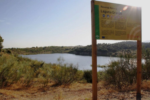
La Reserva Natural Lagunas de Archidona constituye una de las pocas zonas húmedas de Andalucía Oriental. El conjunto lagunar está formado por dos lagunas de tamaño considerable, cuyas aguas son salinas y ricas en sulfatos.
Para el seguimiento ornitolimnológico de humedales se han colocado sondas multiparamétricas instaladas en unas boyas estancas, autónomas energéticamente y que conectadas a Internet. Se toman cada 2 horas, 5 medidas ambientales y aéreas (temperatura, presión barométrica, dirección e intensidad del viento y posición GPS) además de 10 variables sumergidas (Temperatura a 4 profundidades, pH, Oxigeno disuelto, Turbidez, conductividad, salinidad, nitratos, clorofila, profundidad por ultrasonidos).
En el marco del proyecto INDALO las sondas aportarán información como laboratorios para valorar los efectos generados por el Cambio Climático.
The Lagunas de Archidona Natural Reserve constitutes one of the few wetland areas in Eastern Andalusia. The lagoon complex is made up of two lagoons of considerable size, whose waters are saline and rich in sulfates.
For limnological monitoring of wetlands, multiparametric probes have been installed on watertight buoys that are energy autonomous and connected to the Internet. Every 2 hours, 5 environmental and aerial measurements are taken (temperature, barometric pressure, wind direction and intensity and GPS position) in addition to 10 submerged variables (Temperature at 4 depths, pH, Dissolved oxygen, Turbidity, conductivity, salinity, nitrates, chlorophyll, ultrasound depth).
Within the framework of the INDALO project, the probes will provide information as laboratories to assess the effects generated by Climate Change.
Simple
-
Date (Publication)Datumsangaben (Publikation)Date (Publication)Date (Publication)Дата (публикации)Date (Publication)Fecha (Publicación)
- 2024-12-10
-
Forme de la présentationPräsentationsformPresentation formPresentation formФорма представленияPresentation formFormulario de presentación
-
Table numériqueDigitale TabelleDigital tableDigital tableэлектронная таблицаDigital tableTabla digital
-
PropósitoPurpose
-
Monitorización y sistema de alertas en tiempo real para el control de las características fisicoquímicas de la masa de agua de forma continua para complementar el seguimiento de las aves en los humedales.
La necesidad surge cuando se identifica que el seguimiento de humedales sensibles en Andalucía se quedaba incompleto analizando sólo la comunidad de aves, y no integrando las características fisicoquímicas de la masa de agua de forma continua. Se requería tener conocimiento de incidencias puntuales en tiempo real que permitiese a los gestores de los espacios poder actuar (vertidos, cambios bruscos temperatura, etc...).
Monitoring and alert system in real time to control the physicochemical characteristics of the water mass on a continuous basis to complement the monitoring of birds in wetlands.
The need arises when it is identified that the monitoring of sensitive wetlands in Andalusia was left incomplete by analyzing only the bird community, and not integrating the physicochemical characteristics of the water mass on a continuous basis. It was necessary to have knowledge of specific incidents in real time that would allow space managers to act (dumps, sudden changes in temperature, etc...).
-
EtatBearbeitungsstatusStatusStatusСтатусStatusEstado
-
Mise à jour continueKontinuierliche AktualisierungOngoingOngoingпостоянно обновляемыйOn goingEn proceso
- Point of contact
-
Organisation name Individual name Electronic mail address Role Red de Información Ambiental de Andalucía (REDIAM) - Junta de Andalucía
Red de Información Ambiental de Andalucía (REDIAM) - Junta de Andalucía
Servicio de Análisis de la Información Ambiental - Consejería de Sostenibilidad y Medio Ambiente - Junta de Andalucía. - España
Servicio de Análisis de la Información Ambiental - Consejería de Sostenibilidad y Medio Ambiente - Junta de Andalucía. - España
PropriétaireEigentümer / DatenherrOwnerOwnerвладелецOwnerPropietario
-
Fréquence de mise à jourÜberarbeitungsintervallMaintenance and update frequencyMaintenance and update frequencyЧастота обновленияMaintenance and update frequencyMantenimiento y frecuencia de actualización
-
ContinueKontinuierlichContinualContinualпостоянноContinualContinuamente
- Metadata author
-
Organisation name Individual name Electronic mail address Role Red de Información Ambiental de Andalucía (REDIAM) - Junta de Andalucía
Red de Información Ambiental de Andalucía (REDIAM) - Junta de Andalucía
Servicio de Análisis de la Información Ambiental - Consejería de Sostenibilidad y Medio Ambiente - Junta de Andalucía. - España
Servicio de Análisis de la Información Ambiental - Consejería de Sostenibilidad y Medio Ambiente - Junta de Andalucía. - España
Editeur (publication)HerausgeberPublisherPublisherиздательPublisherPublicador
-
ThèmeThemaThemeThemeпредметThemeTema
-
-
Humedal
wetland
-
Laguna
lagoon
-
Limnología
limnology
-
-
LocalisationOrtPlacePlaceместоPlaceLugar
-
-
Andalucía, España
Andalusia, Spain
-
Laguna de Archidona
-
- Keywords
-
-
Contraintes d'accèsZugriffseinschränkungenAccess constraintsAccess constraintsОграничения на получениеAccess constraintsRestricciones de Acceso
-
Autres restrictionsBenutzerdefinierte EinschränkungenOther restrictionsOther restrictionsдругие ограниченияOther restrictionsOtras restricciones
-
Contraintes d'utilisationNutzungseinschränkungenUse constraintsUse constraintsОграничения на использованиеUse constraintsRestricciones de uso
-
Autres restrictionsBenutzerdefinierte EinschränkungenOther restrictionsOther restrictionsдругие ограниченияOther restrictionsOtras restricciones
-
Otras limitacionesOther constraints
-
Creative Commons Attribution 4.0 International Public License (CC BY 4.0)
Creative Commons Attribution 4.0 International Public License (CC BY 4.0)
-
Type de représentation spatialeRäumliche DarstellungsartSpatial representation typeSpatial representation typeТип пространственного представленияSpatial representation typeTipo de representación espacial
-
TabulaireText, TabelleText tableText tableтекст/таблицаText, tableTexto, tabla
-
Langue de la ressourceSpracheLanguageLanguageЯзыкLanguageIdioma
- Spanish; Castilian
-
Encodage des caractèresZeichensatzCharacter setCharacter setКодировкаCharacter setCodificación
-
Utf8Utf8UTF8UTF8utf8UTF8UTF8
-
Catégorie ISOThematikTopic categoryTopic categoryПредметная областьTopic categoryCategoría temática
-
-
Eaux intérieures, HydrographieBinnengewässerInland watersInland watersПоверхностные водыInland watersAguas Interiores
-
EnvironnementUmweltEnvironmentEnvironmentОкружающая средаEnvironmentMedio ambiente
-
))
- OnLine resource
-
Protocol Linkage Name OGC:SOS
https://sos.beta.lifewatch.eu/service?service=SOS&version=2.0.0&request=DescribeSensor&procedure=http://sos.lifewatch.eu/boyasMultiparametricas/_111&procedureDescriptionFormat=http%3A%2F%2Fwww.opengis.net%2Fsensorml%2F2.0 Servicio SOS de acceso a los datos de la sonda multiparamétrica de la Laguna de Archidona
SOS service for access to data from the Laguna Escondida multiparametric probe
- OnLine resource
-
Protocol Linkage Name WWW:LINK-1.0-http--partners
https://sos.beta.lifewatch.eu/api/datasets?services=1&procedures=1094&datasetTypes=timeseries&observationTypes=simple&valueTypes=quantity%2Ccount Servicio de acceso a datos 52 North SensorWeb Server Helgoland
The SensorWeb Server Helgoland API
-
NiveauBezugsebeneHierarchy levelHierarchy levelИерархический уровеньHierarchy levelJerarquía
-
Jeu de donnéesDatenbestandDatasetDatasetнабор данныхDatasetConjunto de datos
Metadata
-
Identifiant de la ficheMetadatensatzidentifikatorFile identifierFile identifierИдентификатор файлаFile identifierIdentificador del fichero
- 9761eb43-759e-441a-b7b2-8a561d91ac4d XML
-
LangueSpracheLanguageLanguageЯзыкMetadata languageIdioma del metadato
- Spanish; Castilian
-
Jeu de caractèresZeichensatzCharacter setCharacter setКодировкаCharacter setCodificación
-
Utf8Utf8UTF8UTF8utf8UTF8UTF8
- Parent identifier
-
Seguimiento limnológico de humedales en Andalucía (España) con datos obtenidos mediante boyas multiparamétricas
d496c106-9132-4fea-99d5-dfe9015cd330
-
Date des métadonnéesDatumDate stampDate stampВремя создания метаданныхDate stampFecha
- 2025-02-25T08:49:16.462197Z
- Metadata standard name
-
ISO 19115:2003/19139
- Metadata standard version
-
1.0
- Metadata author
-
Organisation name Individual name Electronic mail address Role Point de contactAnsprechpartnerPoint of contactPoint of contactконтактное лицоPoint of contactPunto de ContactoRed de Información Ambiental de Andalucía (REDIAM) - Junta de Andalucía
Servicio de Análisis de la Información Ambiental - Consejería de Sostenibilidad y Medio Ambiente - Junta de Andalucía. - España
AuteurAutorAuthorAuthorавторAuthorAutor
- Other language
-
Language Character encoding FrançaisFranzösischFrenchFrenchFrenchFrenchFrenchAllemandDeutschGermanGermanGermanGermanGermanChinois(Other)Chinesisch(Other)Chinese(Other)Chinese(Other)Chinese(Other)Chinese(Other)Chinese(Other)ArabeArabischArabicArabicArabicArabicArabicRusseRussischRussianRussianRussianRussianRussianAnglaisEnglischEnglishEnglishEnglishEnglishEnglishUtf8Utf8UTF8UTF8utf8UTF8UTF8Espagnol; castillanSpanischSpanish; CastilianSpanish; CastilianSpanish; CastilianSpanish; CastilianSpanish; CastilianUtf8Utf8UTF8UTF8utf8UTF8UTF8
Overviews
Spatial extent
Provided by